In 2011 I took a ride in the Western Maryland Rail Road Trail and saw a number of cyclists riding by the side of the train. Shortly thereafter I learned that the trail is part of the Great Allegheny Passage which starts in Cumberland, Maryland and ends in Pittsburgh. I live in Northern Virginia and after some additional research I learned of the C&O Trail which starts in Georgetown, DC and ends in Cumberland.
I had wanted to cycle from Washington DC to Pittsburgh or vice versa for the last 2 years and after weighing the pros and cons of a few different options (cycling with a group or cycling solo, cycling in summer, fall or the spring, cycling from Pittsburgh to DC or from DC to Pittsburgh), I opted to cycle solo from DC to Pittsburgh in the fall of 2016.
Giving the time of the ride (Fall and October), the ride brings forth memories of a colleague of mine Al Selvin who loved cycling and died unfortunately last year while cycling near his home in White Plains, NY.
Details of the plan:
Day 1: Northern Virginia --> Washington DC --> Shepherdstown, West Virginia (~ 78 miles)
Day 2: Shepherdstown,West Virginia to Paw Paw, Maryland (~ 87 miles)
Day 3: Cycle from Paw Paw, Maryland to Rockwood, Pennsylvania (~ 74 miles)
Day 4: Cycle from Rockwood, Pennsylvania to West Newton, Pennsylvania (~71 miles)
Day 5: Cycle from West Newton, Pennsylvania to Point State Park in Pittsburgh (~39 miles)
Day 6: Take the Capital Train 30 from Pittsburgh to Washington DC
From my perspective. this plan was a challenging plan given that I had barely logged 1,000 miles of training in 2016.
A few details about what I used for the bike trip:
Bike - Specialized Tricross 2011 model with 32C tires.
Panniers - Topeak MTX Trunk Bag DXP Bicycle Trunk Bag with Rigid Molded Panels
(This bag comes with expandable panniers ; however it is not considered as typical touring gear)
I also purchased the rain covers for the bag.
Clothing:
Under Armour Long Sleeve Running Shirts
Under Armour Cold Gear Shirt
Specialized Mountain Bike Shorts
Bontrager Bike Shorts
Marmot PreCip Rain Jacket
Electronics
1 Veho VCC-006-K2NPNG (I prefer this to Gopro as it is a better value for money). Also "NPNG" stands for "No proof no glory".
Fuel and Hydration
Gu Energy Gels
Cliff Blocks
Vitamin Water
Day 1 of the Trip (October 21st) - Arlington, VA to Washington DC to Shepherdstown, WV.
Weather: Temperature ~ 66 F, Wet and humid
I started from the town of Arlington in Northern Virginia and used local roads to go to the start of the Key Bridge that leads to George Town.After a couple of local roads, I landed at the intersection of Lee Highway and Fort Myer road which is close to the Rosslyn Key Bridge.
Shortly after crossing the bridge, I entered the busy M Street in Georgetown. From this street, I took a right on 30th street and after a few miscues and some help from another rider, I headed to the Capital Crescent Trail, which is a paved trail that runs parallel to the C&O trail.
I finally started on my way to Cumberland by riding in the Capital Crescent trail before moving over to C&O Canal near mile marker 4 and proceeded to mile marker 5.
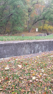
7 or 8 miles later I rode into the part of the C&O Canal where the canal opens up. This particular site appears to be popular with photographers.
A little later I came close to the beautiful Great falls which is a popular place to visit in Washington DC.

After a short time in Great falls I proceeded to Whites Ferry which was my next stop.
There is a ferry here which transports bikes, cars and other vehicles from Whites Ferry (which is in Maryland) to Virginia (nearest city is Leesburg).


After lunch at the White's Ferry restaurant (notice the history of flood), I resumed my trip.
Near the 45 mile marker in C&O Canal trail, it started raining somewhat abruptly and I did not have the time to mount the camera inside the water proof casing. All electronic items went to protective water proof covers and I put on the Marmot rain jacket. For the next 28 miles it never stopped raining completely and even as I pulled into Shepherdstown, WV there was a steady drizzle.
In order to enter the city of Shepherdstown, I needed to go uphill in a winding path with several turns, cross the Potomac river and then had to cycle a couple of miles before arriving at Quality Inn in Shepherdstown. After cleaning the bike I checked into the hotel. The Quality Inn is a bit further away(1/2 mile or so) from the main street(W German Street) in Shepherdstown and since it was raining intermittently I decided not to venture away from from the hotel. In other circumstances, I would have liked to dine in one of the many fine restaurants that Shepherdstown has to offer.
That concludes the first day of my trip from Washington DC to Pittsburgh.
Day 2 of the Trip (October 22nd) - Shepherdstown, WV to Paw Paw, WV
Weather: Temperature ~ 50 F, Cold and windy
After a complementary breakfast of hard boiled eggs, bananas and English muffin at the Quality Inn, I started the second day of my trip from Shepherdstown in sharply different conditions. The temperature had dropped sharply and to make matters worse there was a wind chill factor. I rode a couple of miles in Shepherdstown before entering the trail(Mile Marker 73).
The surface of this section of the trail feels like an unfinished garage. There are a lot of broken branches that can have the effect of causing damage to the bike and to you if you fall of the bike.
A few miles later, I saw the first of many dams in the C&O trail.

A few miles later things improved substantially as the trail positioned itself right next to the Potomac river. This section of the trail (around mile marker 85) is scenic and appears to be well maintained.
Three hours later I reached the 100 mile marker as I passed thru the town of Williamsport.
Even though it was sunny, the temperature barely crept up and the winds persisted.

In the stretch between Williamsport (Mile Marker ~ 99) and Hancock (~124), I stopped by briefly by a 230 year old mill which was apparently damaged by a flood.

Finally after 2 and a half hours, I arrived in Hancock where I stopped by for lunch.
After a delicious lunch of fish and chips at Buddy Lou's in Hancock, I re-embarked on my journey. It was around 2:00 PM around this time and I had another 32 miles to cover before I reached close to Paw Paw which was going to be my resting place for the night.
This section between Hancock and Paw Paw seems to be very isolated and I rode for nearly 20 miles (2 hours) without running into any hiker or rider. I paused for a brief moment near one of the canal locks (and the C&O has 74 of these locks).
Shortly after passing this lock (Lock #59) I ran suddenly into two hunters who emerged from behind the bushes. They stated that they were lost and wanted to get a sense of the position of the river. After I provided them with clarification they inquired if I had seen any bears. They noted that they have seen a few bears and wished me safe passage. At this point, I was not sure which of the two, the presence of hunters or the possible presence of bears were more frightening. I picked up my speed to proceed to my next stop at the 150 mile marker.

5 miles later I encountered a unique destination in the trail which is the Paw Paw Tunnel. This tunnel is pitch dark and has a very narrow passage. Apparently the tunnel was considered as one of the great engineering feats of its period and there is quite a bit of interesting history about the tunnel.
Finally after passing the tunnel, I took yet one more diversion from the tunnel to the little town of Paw Paw in West Virginia. Here I was going to stay at the Wrenwood Inn for the night.
I had some really good food and company at the Wrenwood Inn. Carol cooked some really nice food (soup, fantastic garlic bread and great chicken salad with a motley of fruits). I had some great company with a couple from Woodbridge which is also a town in Northern Virginia.
However shortly after dinner, I started suffering from a severe pain in my right foot. The pain was severe enough to prevent me from placing my foot on the floor. Carol came to the rescue and provided me with a hot compress, which I used extensively for an hour to relieve the pain. I also took a couple of Ibuprofen and that also helped. However for some reason, I could not get sleep easily that night, which would present me with a challenge in the next day.
That concludes the second day of my trip from Washington DC to Pittsburgh.
Day 3 of the Trip (October 23rd) - Paw Paw, WV to Rockwood, PA
Weather: Temperature ~ 50 F, Cold and windy
After a poor night of sleeping, I was nervous about riding in the 3rd day. I had not attempted anything greater than 150 miles over a 2 day stretch and so any new miles logged in the 3rd day and beyond would be a personal record. After breakfast I left Paw Paw at around 745 AM.
10 miles later the trail appeared to be surrounded by more open spaces. I continued to pass the last few remaining canal locks and the lock houses that were positioned next to the canal locks. The park service has now started renting some of these lock houses to trail riders.
At the 176 mile marker I started seeing some hills in the horizon. The trail appeared to be wet and the surface here felt like that it was made of clay. There were a lot of visible cycle marks in the trail in this section of the trail.
Video of the home stretch --- leading to 184 miles in C&O Trail....
Finally 18 miles later, I arrived at what appeared to be the end of the C&O trail at mile marker 184. The Potomac river had narrowed down considerably at this point.


I then proceeded thru downtown Cumberland and started on the Great Allegheny Passage (GAP) trail. For the first time in the ride, I was able to strike a conversation albeit for a brief moment with a couple of cyclist cycling from Cumberland to Frostburg.
Initially the GAP trail starts of as a paved trail. The trail has a steady uphill climb and it does not feel that daunting as I expected. Once you are accustomed to the uphill climb and reduce the speed, the climb is tolerable.
Near the 16 mile marker, I went to the town of Frostburg. Here I learned of the closure of the Frostburg station because land slides had resulted in cancellation of the Western Maryland train ride to Frostburg. This has caused significant economic impact to the small businesses in Frostburg.
At the 16 mile marker near Frostburg, VA (I had now covered 200 of the trail, 184 miles or so of the C&O Trail and a further 16 miles of the GAP trail))

After a delayed lunch in Frostburg, I took the winding downhill trail from the town to the trail and resumed my ride in the GAP trail. At this point the trail was still steadily going uphill.
Near the 20 mile marker I closed the Mason Dixon line. This line also separates the state of Maryland from Pennsylvania.


Shortly thereafter I arrived at the entrance of the Great Savage tunnel.

I had run out of space in micro SD disk and so could no longer use the camera. However I found a YouTube posting of the tunnel from another rider.
2 miles from the Great Savage tunnel, I arrived at the Eastern Continental Divide. This the high point of the entire ride from Washington DC to Pittsburgh.

I then proceeded to Rockwood. I encountered the first of many bridges in the GAP in this section from Eastern Continental Divide to Rockwood.

I finally arrived in Rockwood around 530 in the evening and proceeded to check into the Rockwood Trail House Bed and Breakfast.
The saddle sores had now firmly taken plant and were beginning to cause considerable irritation and pain. This is despite the generous application of Chamois Cream. Fortunately from me, a fellow bed and breakfast customer loaned me an antiseptic cream (Neosprene). I took a chance and applied it, hoping for the best.
None of the restaurants appeared to be open in Rockwood. I settled to take a large pizza from the local gas station as my dinner.
Meanwhile the situation with my electronic gadgets took a turn for the worse as my cell phone decided to shut down and I was asked to re-initiate the setup process.
That concludes the third day of my trip from Washington DC to Pittsburgh.
Day 4 of the Trip (October 24th) - Rockwood, PA to Whitsett, PA
Weather: Temperature ~ 50 F, Cold and windy
After a nice breakfast of eggs and banana at the B&B, I re-stocked on my fuel (Gu and Cliff Bar) and resumed my ride. I was hoping to get a new micro SD card in the local bike shop, but there was no card available.
The stretch from Rockwood to Ohiopyle had a lot of leaves on the trail,
The wind and the clouds continue to persist for most of this stretch.
The effect of the saddle sore seemed to slow me down considerably and also impaired my mobility in terms of changing my seating position in the saddle.
Some time later I arrived at the 66 mile marker (250 miles of the trail):

I arrived in Ohiopyle around 11:30 and was glad to hear that the nearby Wilderness Voyagers had the micro SD card. I proceeded to take an early lunch, charge my cell phone and also purchased the additional micro SD card.
I then resumed my journey towards Connellsville. armed with a charged phone and new micro SD card. A rider who rode from Pittsburgh informed me that the stretch between Ohiopyle and Connellsville is scenic and that proved to be true.
About 4 miles from Connellsville, I took a brief break to savor the scenery and the trains. the sounds of which seem to be a constant during the entire ride.
About 4 miles from Connellsville, I took a brief break to savor the scenery and the trains. the sounds of which seem to be a constant during the entire ride.
Despite the sunny conditions, the wind persisted and so the temperatures did not budge much the entire day. I used my rain jacket to protect me from wind and to my relief, it fared well.
I stopped by at Connellsville. Notice the little elevation map on the bottom of the photograph. That gives an idea of how much I have traveled and the extent of elevation in the trip.

The stretch from Connelsville to West Newton was lonely and I do not recall running into any rider or person in that entire stretch.
I stopped by the 100 mile marker to take a breather.


Day 5 of the Trip (October 25th) - West Newton, PA to
After a relaxing breakfast in Bright Morning B&B, I resumed my ride from West Newton near the 114 mile marker. The temperature was barely 40 F. The first few miles seemed to take on a semi rural environment with houses in the right and left of the trail.
After 15 miles, I stopped by the town of New Boston.
Shortly after cross Boston the trail took a different feel especially in McKeesport. The trail passes by the side of a few enterprises that bring out the industrial character of the city. Also in some cases the trail and the road are on and the same. You have to pay specific attention to the numerous GAP trail markings along the way to stay on track.
This is the first point at which the trail and the road become one.
Still further ahead the trail then enters what appears to be in the middle of the town with different residences and companies. It is a dramatically different from earlier portions of the trail. You can relate to the steel city as remnants of what appear to be steel companies start appearing next to the trail.
Fortunately there are several markers that provide a clear path in the middle of the city, as you will see in this video below.
Shortly after this the GAP trail appears to become part of the Steel City Trail.
One of the thing that continues to surprise me is the number of "trail" bridges that are just meant only to serve trail riders, runners and walkers. In my mind this investment in bike trails is unprecedented and I doubt if there is any equivalent of this trail in any other state.
The steel city trail is mostly paved and the other thing that never ceases is the number of trains that run side by side by the trail. At this point, I felt that there was always some training passing me in one of the directions.
The trail then proceeds to what appears to be one of the suburbs of Pittsburgh by the name of Homestead. The scenery now changes from the industrial to the suburban.
A restaurant that I highly recommend is the Mitchell's fish markets. The service might seem a bit slow, but the food quality is excellent.
Finally I left Homestead for Pittsburgh and the scenery changes again to the thriving downtown of Pittsburgh. Seldom, in one day during a bike ride I have seen such a variance in scenery.
After a few wrong turns, I reached the end point of the ride at Point State Park.

Day 6 (Pittsburgh to DC).
I took the Capital Train 30 (starting from Chicago) to return to Washington DC. The Pittsburgh Amtrak station is located in downtown Pittsburgh and I cycled from my Hotel (Hampton Inn) to the station. The station is located about half a mile from the hotel.
The train arrived in time(5:00 AM) and the cyclists are called first to mount their bikes in a separate bike compartment. Mounting the bike is fairly straightforward and takes 5 minutes.

The roomette was comfortable and I was fortunate to have the entire roomette to myself.
The train arrived in DC about 45 minutes late. I was able to take the DC Metro to reach my car in Falls Church and drive home. Note that I was able to take my bike in DC Metro since I was transporting the bike outside of rush hours.
This concludes my trip.
Please consider donating to:
Charities near and dear to Al's heart:
Maintaining the C&O trail or the GAP Trail:
I had wanted to cycle from Washington DC to Pittsburgh or vice versa for the last 2 years and after weighing the pros and cons of a few different options (cycling with a group or cycling solo, cycling in summer, fall or the spring, cycling from Pittsburgh to DC or from DC to Pittsburgh), I opted to cycle solo from DC to Pittsburgh in the fall of 2016.
Giving the time of the ride (Fall and October), the ride brings forth memories of a colleague of mine Al Selvin who loved cycling and died unfortunately last year while cycling near his home in White Plains, NY.
Details of the plan:
Day 1: Northern Virginia --> Washington DC --> Shepherdstown, West Virginia (~ 78 miles)
Day 2: Shepherdstown,West Virginia to Paw Paw, Maryland (~ 87 miles)
Day 3: Cycle from Paw Paw, Maryland to Rockwood, Pennsylvania (~ 74 miles)
Day 4: Cycle from Rockwood, Pennsylvania to West Newton, Pennsylvania (~71 miles)
Day 5: Cycle from West Newton, Pennsylvania to Point State Park in Pittsburgh (~39 miles)
Day 6: Take the Capital Train 30 from Pittsburgh to Washington DC
From my perspective. this plan was a challenging plan given that I had barely logged 1,000 miles of training in 2016.
A few details about what I used for the bike trip:
Bike - Specialized Tricross 2011 model with 32C tires.
Panniers - Topeak MTX Trunk Bag DXP Bicycle Trunk Bag with Rigid Molded Panels
(This bag comes with expandable panniers ; however it is not considered as typical touring gear)
I also purchased the rain covers for the bag.
Clothing:
Under Armour Long Sleeve Running Shirts
Under Armour Cold Gear Shirt
Specialized Mountain Bike Shorts
Bontrager Bike Shorts
Marmot PreCip Rain Jacket
Electronics
1 Veho VCC-006-K2NPNG (I prefer this to Gopro as it is a better value for money). Also "NPNG" stands for "No proof no glory".
Fuel and Hydration
Gu Energy Gels
Cliff Blocks
Vitamin Water
Day 1 of the Trip (October 21st) - Arlington, VA to Washington DC to Shepherdstown, WV.
Weather: Temperature ~ 66 F, Wet and humid
I started from the town of Arlington in Northern Virginia and used local roads to go to the start of the Key Bridge that leads to George Town.After a couple of local roads, I landed at the intersection of Lee Highway and Fort Myer road which is close to the Rosslyn Key Bridge.
Shortly after crossing the bridge, I entered the busy M Street in Georgetown. From this street, I took a right on 30th street and after a few miscues and some help from another rider, I headed to the Capital Crescent Trail, which is a paved trail that runs parallel to the C&O trail.
I finally started on my way to Cumberland by riding in the Capital Crescent trail before moving over to C&O Canal near mile marker 4 and proceeded to mile marker 5.
7 or 8 miles later I rode into the part of the C&O Canal where the canal opens up. This particular site appears to be popular with photographers.
A little later I came close to the beautiful Great falls which is a popular place to visit in Washington DC.

After a short time in Great falls I proceeded to Whites Ferry which was my next stop.
There is a ferry here which transports bikes, cars and other vehicles from Whites Ferry (which is in Maryland) to Virginia (nearest city is Leesburg).

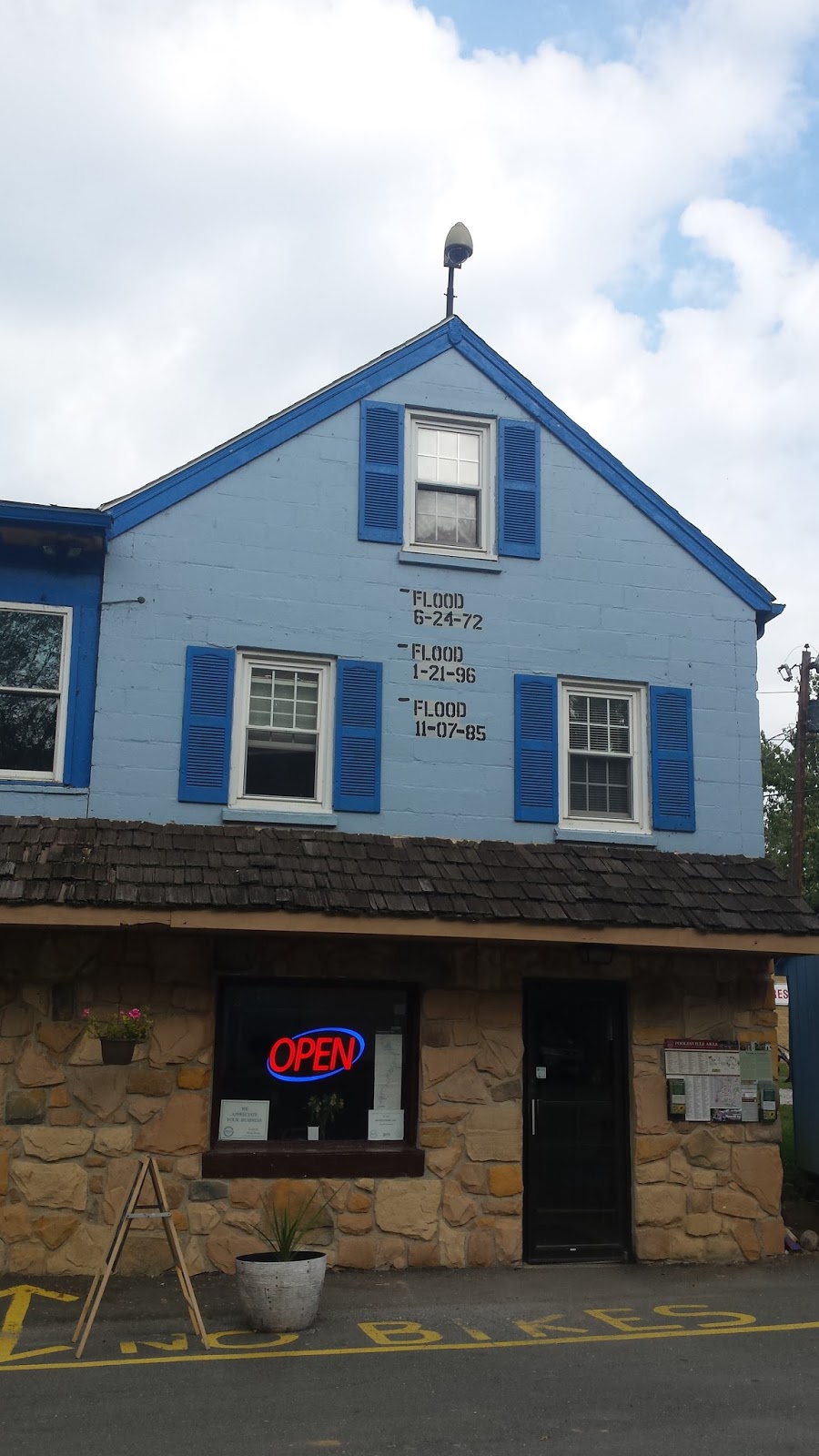
After lunch at the White's Ferry restaurant (notice the history of flood), I resumed my trip.
Near the 45 mile marker in C&O Canal trail, it started raining somewhat abruptly and I did not have the time to mount the camera inside the water proof casing. All electronic items went to protective water proof covers and I put on the Marmot rain jacket. For the next 28 miles it never stopped raining completely and even as I pulled into Shepherdstown, WV there was a steady drizzle.
In order to enter the city of Shepherdstown, I needed to go uphill in a winding path with several turns, cross the Potomac river and then had to cycle a couple of miles before arriving at Quality Inn in Shepherdstown. After cleaning the bike I checked into the hotel. The Quality Inn is a bit further away(1/2 mile or so) from the main street(W German Street) in Shepherdstown and since it was raining intermittently I decided not to venture away from from the hotel. In other circumstances, I would have liked to dine in one of the many fine restaurants that Shepherdstown has to offer.
That concludes the first day of my trip from Washington DC to Pittsburgh.
Day 2 of the Trip (October 22nd) - Shepherdstown, WV to Paw Paw, WV
Weather: Temperature ~ 50 F, Cold and windy
After a complementary breakfast of hard boiled eggs, bananas and English muffin at the Quality Inn, I started the second day of my trip from Shepherdstown in sharply different conditions. The temperature had dropped sharply and to make matters worse there was a wind chill factor. I rode a couple of miles in Shepherdstown before entering the trail(Mile Marker 73).
The surface of this section of the trail feels like an unfinished garage. There are a lot of broken branches that can have the effect of causing damage to the bike and to you if you fall of the bike.
A few miles later, I saw the first of many dams in the C&O trail.

A few miles later things improved substantially as the trail positioned itself right next to the Potomac river. This section of the trail (around mile marker 85) is scenic and appears to be well maintained.
Three hours later I reached the 100 mile marker as I passed thru the town of Williamsport.
Even though it was sunny, the temperature barely crept up and the winds persisted.

In the stretch between Williamsport (Mile Marker ~ 99) and Hancock (~124), I stopped by briefly by a 230 year old mill which was apparently damaged by a flood.

Finally after 2 and a half hours, I arrived in Hancock where I stopped by for lunch.
After a delicious lunch of fish and chips at Buddy Lou's in Hancock, I re-embarked on my journey. It was around 2:00 PM around this time and I had another 32 miles to cover before I reached close to Paw Paw which was going to be my resting place for the night.
This section between Hancock and Paw Paw seems to be very isolated and I rode for nearly 20 miles (2 hours) without running into any hiker or rider. I paused for a brief moment near one of the canal locks (and the C&O has 74 of these locks).

Shortly after passing this lock (Lock #59) I ran suddenly into two hunters who emerged from behind the bushes. They stated that they were lost and wanted to get a sense of the position of the river. After I provided them with clarification they inquired if I had seen any bears. They noted that they have seen a few bears and wished me safe passage. At this point, I was not sure which of the two, the presence of hunters or the possible presence of bears were more frightening. I picked up my speed to proceed to my next stop at the 150 mile marker.

5 miles later I encountered a unique destination in the trail which is the Paw Paw Tunnel. This tunnel is pitch dark and has a very narrow passage. Apparently the tunnel was considered as one of the great engineering feats of its period and there is quite a bit of interesting history about the tunnel.
Finally after passing the tunnel, I took yet one more diversion from the tunnel to the little town of Paw Paw in West Virginia. Here I was going to stay at the Wrenwood Inn for the night.
I had some really good food and company at the Wrenwood Inn. Carol cooked some really nice food (soup, fantastic garlic bread and great chicken salad with a motley of fruits). I had some great company with a couple from Woodbridge which is also a town in Northern Virginia.
However shortly after dinner, I started suffering from a severe pain in my right foot. The pain was severe enough to prevent me from placing my foot on the floor. Carol came to the rescue and provided me with a hot compress, which I used extensively for an hour to relieve the pain. I also took a couple of Ibuprofen and that also helped. However for some reason, I could not get sleep easily that night, which would present me with a challenge in the next day.
That concludes the second day of my trip from Washington DC to Pittsburgh.
Day 3 of the Trip (October 23rd) - Paw Paw, WV to Rockwood, PA
Weather: Temperature ~ 50 F, Cold and windy
After a poor night of sleeping, I was nervous about riding in the 3rd day. I had not attempted anything greater than 150 miles over a 2 day stretch and so any new miles logged in the 3rd day and beyond would be a personal record. After breakfast I left Paw Paw at around 745 AM.
10 miles later the trail appeared to be surrounded by more open spaces. I continued to pass the last few remaining canal locks and the lock houses that were positioned next to the canal locks. The park service has now started renting some of these lock houses to trail riders.
At the 176 mile marker I started seeing some hills in the horizon. The trail appeared to be wet and the surface here felt like that it was made of clay. There were a lot of visible cycle marks in the trail in this section of the trail.
Video of the home stretch --- leading to 184 miles in C&O Trail....
Finally 18 miles later, I arrived at what appeared to be the end of the C&O trail at mile marker 184. The Potomac river had narrowed down considerably at this point.


I then proceeded thru downtown Cumberland and started on the Great Allegheny Passage (GAP) trail. For the first time in the ride, I was able to strike a conversation albeit for a brief moment with a couple of cyclist cycling from Cumberland to Frostburg.
Initially the GAP trail starts of as a paved trail. The trail has a steady uphill climb and it does not feel that daunting as I expected. Once you are accustomed to the uphill climb and reduce the speed, the climb is tolerable.
Near the 16 mile marker, I went to the town of Frostburg. Here I learned of the closure of the Frostburg station because land slides had resulted in cancellation of the Western Maryland train ride to Frostburg. This has caused significant economic impact to the small businesses in Frostburg.
At the 16 mile marker near Frostburg, VA (I had now covered 200 of the trail, 184 miles or so of the C&O Trail and a further 16 miles of the GAP trail))

After a delayed lunch in Frostburg, I took the winding downhill trail from the town to the trail and resumed my ride in the GAP trail. At this point the trail was still steadily going uphill.
Near the 20 mile marker I closed the Mason Dixon line. This line also separates the state of Maryland from Pennsylvania.


Shortly thereafter I arrived at the entrance of the Great Savage tunnel.

I had run out of space in micro SD disk and so could no longer use the camera. However I found a YouTube posting of the tunnel from another rider.
2 miles from the Great Savage tunnel, I arrived at the Eastern Continental Divide. This the high point of the entire ride from Washington DC to Pittsburgh.

I then proceeded to Rockwood. I encountered the first of many bridges in the GAP in this section from Eastern Continental Divide to Rockwood.

I finally arrived in Rockwood around 530 in the evening and proceeded to check into the Rockwood Trail House Bed and Breakfast.
The saddle sores had now firmly taken plant and were beginning to cause considerable irritation and pain. This is despite the generous application of Chamois Cream. Fortunately from me, a fellow bed and breakfast customer loaned me an antiseptic cream (Neosprene). I took a chance and applied it, hoping for the best.
None of the restaurants appeared to be open in Rockwood. I settled to take a large pizza from the local gas station as my dinner.
Meanwhile the situation with my electronic gadgets took a turn for the worse as my cell phone decided to shut down and I was asked to re-initiate the setup process.
That concludes the third day of my trip from Washington DC to Pittsburgh.
Day 4 of the Trip (October 24th) - Rockwood, PA to Whitsett, PA
Weather: Temperature ~ 50 F, Cold and windy
After a nice breakfast of eggs and banana at the B&B, I re-stocked on my fuel (Gu and Cliff Bar) and resumed my ride. I was hoping to get a new micro SD card in the local bike shop, but there was no card available.
The stretch from Rockwood to Ohiopyle had a lot of leaves on the trail,
The wind and the clouds continue to persist for most of this stretch.
The effect of the saddle sore seemed to slow me down considerably and also impaired my mobility in terms of changing my seating position in the saddle.
Some time later I arrived at the 66 mile marker (250 miles of the trail):

I arrived in Ohiopyle around 11:30 and was glad to hear that the nearby Wilderness Voyagers had the micro SD card. I proceeded to take an early lunch, charge my cell phone and also purchased the additional micro SD card.
I then resumed my journey towards Connellsville. armed with a charged phone and new micro SD card. A rider who rode from Pittsburgh informed me that the stretch between Ohiopyle and Connellsville is scenic and that proved to be true.
About 4 miles from Connellsville, I took a brief break to savor the scenery and the trains. the sounds of which seem to be a constant during the entire ride.
About 4 miles from Connellsville, I took a brief break to savor the scenery and the trains. the sounds of which seem to be a constant during the entire ride.
Despite the sunny conditions, the wind persisted and so the temperatures did not budge much the entire day. I used my rain jacket to protect me from wind and to my relief, it fared well.
I stopped by at Connellsville. Notice the little elevation map on the bottom of the photograph. That gives an idea of how much I have traveled and the extent of elevation in the trip.

The stretch from Connelsville to West Newton was lonely and I do not recall running into any rider or person in that entire stretch.
I stopped by the 100 mile marker to take a breather.


Day 5 of the Trip (October 25th) - West Newton, PA to
Weather: Temperature ~ 45 F, Cold and windy
After a relaxing breakfast in Bright Morning B&B, I resumed my ride from West Newton near the 114 mile marker. The temperature was barely 40 F. The first few miles seemed to take on a semi rural environment with houses in the right and left of the trail.
After 15 miles, I stopped by the town of New Boston.
Shortly after cross Boston the trail took a different feel especially in McKeesport. The trail passes by the side of a few enterprises that bring out the industrial character of the city. Also in some cases the trail and the road are on and the same. You have to pay specific attention to the numerous GAP trail markings along the way to stay on track.
This is the first point at which the trail and the road become one.
Still further ahead the trail then enters what appears to be in the middle of the town with different residences and companies. It is a dramatically different from earlier portions of the trail. You can relate to the steel city as remnants of what appear to be steel companies start appearing next to the trail.
Fortunately there are several markers that provide a clear path in the middle of the city, as you will see in this video below.
Shortly after this the GAP trail appears to become part of the Steel City Trail.
One of the thing that continues to surprise me is the number of "trail" bridges that are just meant only to serve trail riders, runners and walkers. In my mind this investment in bike trails is unprecedented and I doubt if there is any equivalent of this trail in any other state.
The steel city trail is mostly paved and the other thing that never ceases is the number of trains that run side by side by the trail. At this point, I felt that there was always some training passing me in one of the directions.
The trail then proceeds to what appears to be one of the suburbs of Pittsburgh by the name of Homestead. The scenery now changes from the industrial to the suburban.
A restaurant that I highly recommend is the Mitchell's fish markets. The service might seem a bit slow, but the food quality is excellent.
Finally I left Homestead for Pittsburgh and the scenery changes again to the thriving downtown of Pittsburgh. Seldom, in one day during a bike ride I have seen such a variance in scenery.
After a few wrong turns, I reached the end point of the ride at Point State Park.

Day 6 (Pittsburgh to DC).
I took the Capital Train 30 (starting from Chicago) to return to Washington DC. The Pittsburgh Amtrak station is located in downtown Pittsburgh and I cycled from my Hotel (Hampton Inn) to the station. The station is located about half a mile from the hotel.
The train arrived in time(5:00 AM) and the cyclists are called first to mount their bikes in a separate bike compartment. Mounting the bike is fairly straightforward and takes 5 minutes.

The roomette was comfortable and I was fortunate to have the entire roomette to myself.
The train arrived in DC about 45 minutes late. I was able to take the DC Metro to reach my car in Falls Church and drive home. Note that I was able to take my bike in DC Metro since I was transporting the bike outside of rush hours.
This concludes my trip.
Please consider donating to:
Charities near and dear to Al's heart:
Maintaining the C&O trail or the GAP Trail:
Just breathtakingly wonderful Narayan. It's a feat actually. I am very glad to respond to my request
ReplyDeleteJust breathtakingly wonderful Narayan. It's a feat actually. I am very glad to respond to my request
ReplyDeleteIt looks like, the most adventurous ride!!!
ReplyDeleteAwesome Sri... for biking alone for 350 miles... not at all easy.
Hearty congratulations!!!
Dear Narayan, Congratulations for the great adventure you have undertaken. We are very much impressed with your rare experience. We wish you many more such adventures. Regards, Aunty & Uncle
ReplyDeleteHello Ryan!!
ReplyDeleteI got your link off the C&O/ GAP website. Thanks for sharing your trip. I am putting together a trip to ride this, summer 2017. I think I will go in the opposite direction because my sister lives in Leesburg and I can start there and ride down to DC, catch the train up to Pittsburgh and ride back to my sister's house. I am trying to plan the number of days to ride. I see you did five days and looked like most of your days were in the 70 to 80 miles per day. Did you find that a tough day of riding??? Did you feel like you were pushing or had time to look around and enjoy the areas?? I have done multiple trips on rail trails and have done some long days (80 miles on one of my days on the Katy trail) but also like the 40 miles days with some sightseeing. Thanks for your thoughts.
Happy trails, Jim
Hi Jim,
ReplyDeleteI did not feel like I was pushing it in any of the days. However I would have felt differently during summer without any doubt.
I had plenty of time to pause and enjoy the ride.
Good luck and hope that you enjoy the ride.
Regards
Ryan